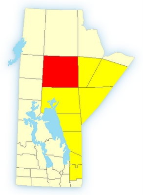
Warnings
Thompson, Thicket Portage and Pikwitonei
4:39 PM CDT Monday 31 July 2006
Tornado warning for
Thompson, Thicket Portage and Pikwitonei issued
Persons in or near this area should be on the lookout for adverse weather conditions and take necessary safety precautions. Watch for updated statements.
Please refer to the latest public forecasts for further details and continue to monitor the situation through your local radio and television stations or Weatheradio.
Split Lake and York Landing
4:34 PM CDT Monday 31 July 2006
Severe thunderstorm warning for
Split Lake and York Landing issued
At 4:30 PM, satellite imagery and lightning detectors indicate a potentially severe thunderstorm near kelsey. This storm is tracking towards the east-northeast.
A low pressure system near Flin Flon is tracking eastward across central Manitoba today. Thunderstorms have already formed, and due to the unstable airmass in place, some of these could become severe.
Watches
Thompson - Nelson House - Split Lake
4:40 PM CDT Monday 31 July 2006
Severe thunderstorm watch for
Thompson - Nelson House - Split Lake continued
Severe thunderstorms are possible over portions of central and northern Manitoba this afternoon.
This is an alert to the potential development of severe thunderstorms with large hail and damaging winds.
Monitor weather conditions..Listen for updated statements. If threatening weather approaches take immediate safety precautions.
At 4:30 PM, satellite imagery and lightning detectors indicate a potentially severe thunderstorm near kelsey. This storm is tracking towards the east-northeast.
A low pressure system near Flin Flon is tracking eastward across central Manitoba today. Thunderstorms have already formed, and due to the unstable airmass in place, some of these could become severe.


0 Responses to “Tornado Warning in Manitoba”
Post a Comment